


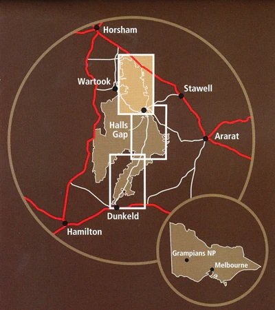
The Grampians Peak Trail South Map covers this section of Victoria’s newest long-distance trail.
Established by Parks Victoria, the trail starts in the north of the Grampians at Mt Zero and finishes 164kms later in Dunkeld. Designed as a 12-13 day trip, it can be done in sections.
This map covers the southern section at 1:50,000 from Jimmy Creek Road to Dunkeld
Well presented, this map covers all you need to know while on the walk.
Other sections available at the Central and North maps.
- 1:50,000 Scale Map
- Easy to read format
- Detailed topographic coverage
- Route notes & planning information
- Descriptions of side trips
- Edition: 1st
- Publication Date: 01/06/21
- Scale: 1:50,000
- Folded size (WxHxD): 100mm x 250mm x 3mm
- Flat size (WxH): 700mm x 1000mm
Be the first to review “Parks Victoria Grampians Peak Trail South Map”
Related products

Parks Victoria
$18.95

$14.95
$11.95
SV Maps
$14.95
Rooftop's
$12.95

$14.95

$12.95
Reviews
There are no reviews yet.